The Old West was a fascinating place…Indians, outlaws and larger than life characters that now only exist in faded old photographs and our memories.
Two of my past posts Old Colorado Homestead and Schweiger Ranch are about old Colorado homesteads and a long lost way of life when people were, I want to say tougher, at least in comparison to today’s standards, but maybe it’s more that they were willing to take huge risks in order to obtain a new life.
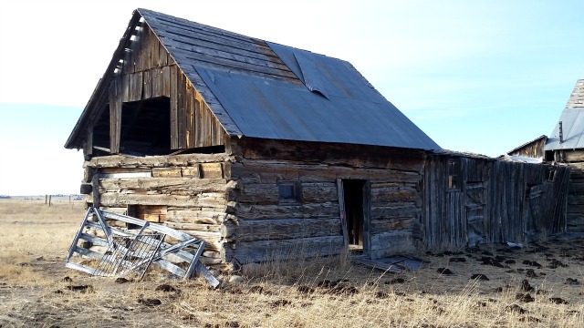
With all of this in mind, I set off on a search to uncover the history of our ranch property. Very few clues existed that even indicated anyone had ever lived here. No foundations, wells or structures of any kind, just a tantalizing bit of rusted metal sticking out from the dirt in our horse pasture, but more about that later.
With our survey plat in hand, I began searching the internet for information, some of which is public such as the Bureau of Land Management website and Family Search.where I was able to find old US Census records, all original and handwritten which I found amazing, as well as some family photographs.
What is a Survey Plat?
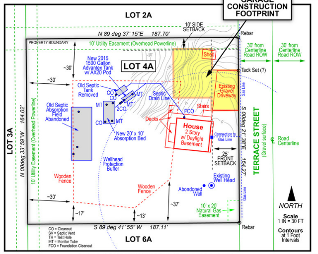
This is not our property, but it gives a good representation of a survey plat
A plat map provides a physical representation of a property, including structures, boundaries, easements, etc. It is drawn to scale and provides accurate measurements of buildings, for example, and where they sit on the property in relation to property boundaries. Prior to purchasing our property, we had a surveyor come out and create a new plat map to ensure that what we were buying was in fact ours.
All US lands in the public domain are subdivided into a rectangular system of surveys, known as the Public Land Survey System (PLSS) which is regulated by the U.S. Department of the Interior, Bureau of Land Management (BLM).
Originally proposed by Thomas Jefferson, the PLSS began shortly after the Revolutionary War, when the Federal government became responsible for large areas west of the thirteen original colonies. The government wished both to distribute land to Revolutionary War soldiers in reward for their service, as well as to sell land as a way of raising money for the nation. Before this could happen, the land needed to be surveyed.
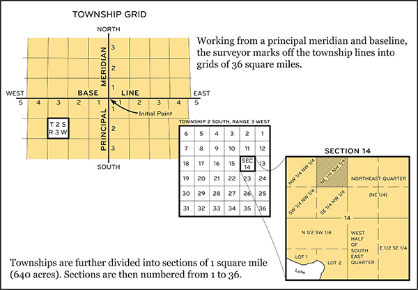
The PLSS typically divides land into 6-mile-square townships. Townships are subdivided into 36 one-mile- square sections. Sections can be further subdivided into quarter sections, quarter-quarter sections, or irregular government lots. Normally, a permanent monument, or marker, is placed at each section corner. Monuments are also placed at quarter-section corners and at other important points, such as the corners of government lots. Today permanent monuments are usually inscribed tablets set on iron rods or in concrete. The original PLSS surveys were often marked by wooden stakes or posts, marked trees, pits, or piles of rock, or other less-permanent markers.
 Loading...
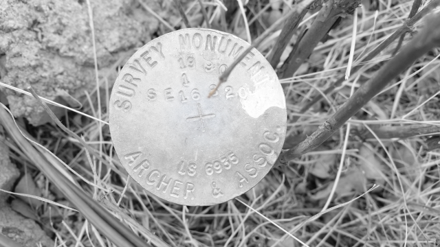
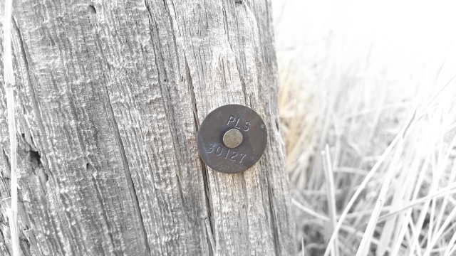
The original land survey, which was performed in the late fall of 1866, used stones as monuments, but sadly, I have never found an original one. However, I have found our modern day metal monuments.
The Homestead Act of 1862, which was signed in to law by Abraham Lincoln, offered free land to any American willing to make it productive. Prior homestead acts had allowed land to be purchased, or allowed special land claims for veterans, but it was the Homestead Act of 1862 that truly opened the American West for settlement in a way no other legislation had before. An interesting document, whose accuracy I cannot vouch for, Free Homestead Lands of Colorado Described: A Handbook for Settlers, provides some interesting insight into what was involved in homesteading.
In 1881, Joseph Plant Sr, his wife, and their 7 children left England and sailed to a better life in the United States. Settling in Denver, where according to the 1885 census Joe Sr was a bricklayer, the family eventually homesteaded 160 acres in Eastern Colorado and obtained the patent for that land in 1898.
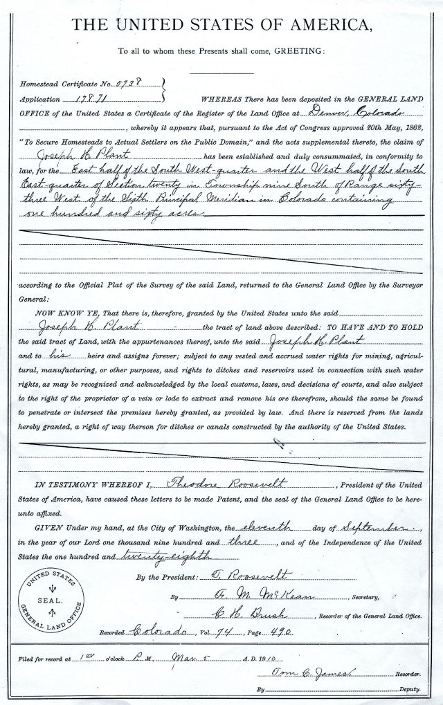
That same year, Joseph Jr filed to homestead 160 acres of land (we live on 80 of those acres) just to the north his family’s homestead where he had grown up.
The fall of 1903 was a busy one for Joseph. On September 11th he received his patent for the 160 acres of land, free and clear, from the US Government and on October 9th he married a lovely local girl named Katie.
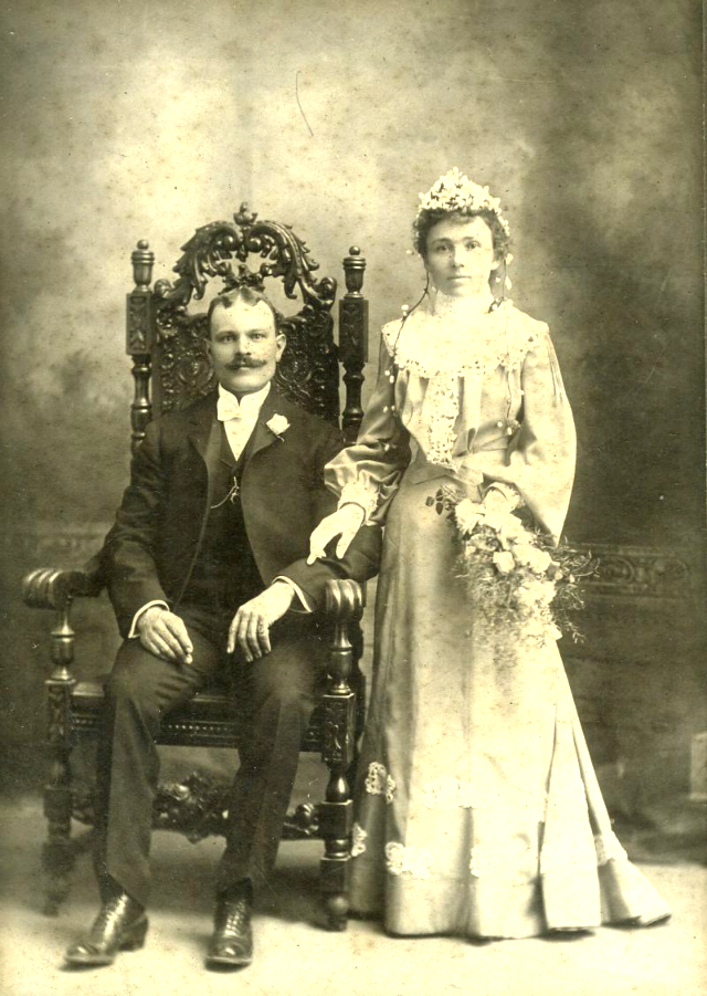
Joseph and his bride remained on the land for a few years and then, according to the 1910 census, he and Katie were living in Denver and had sold their property to Joseph’s brother, Willie, who then lived on the land with his family until he sold the ranch in 1948.
Our property changed hands several times, and as far as I can tell, no one lived on the land until the owners prior to us bought it and split it into two 80 acres plots.
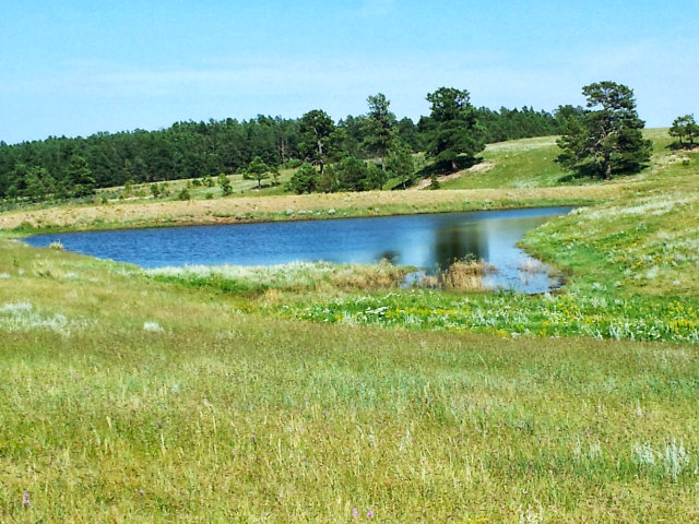
Almost no trace of previous inhabitants could be found, but there are a few breadcrumbs lying about. The back 40 acres of our property has a seasonal pond with an earthen damn. I do not know when or how this was built, but I suspect it was during the Depression when the CCC was in our county doing work.
On the other side of the damn, I found a partially buried and crushed Aermotor Windmill and not too far from it some sort of a pump. Aermotor’s have been produced since the late 1800’s so it is entirely possible that this windmill was part of the original homestead.
My exploration in to the history of our property was fascinating. Being able to touch and see handwritten records from, in some cases, just after the Civil War, was truly amazing. I am one of those people who looks at a landscape and tries to envision it when it was devoid of civilization as we know it. What drove people to come to the west and all the hardships involved in doing that? And how in the world they ever survived without a cell phone is beyond my comprehension (sorry, couldn’t help myself, had to throw that in there 🙂 )
If you enjoy this type of research/detective work as I do, you are probably wondering how did I find some of my information. There are a lot of great resources out there, sometimes all it takes is the persistence and perseverance to find them.
Our local Abstract Title office was very helpful. They have handwritten books going back to the 1800s with all of the transactions that occurred on individual properties. They are not always easy to decipher as there are lots of abbreviations and difficult to read handwriting, but you can certainly gain insight into the history of your property.
I found quite a bit of online information through History Colorado as well as the Denver Public Library. Old online newspapers are also a great source of information.
If you are interested in your property’s history or even family genealogy, I would love to hear from you.
Until next time, Happy Trails!
![]()
Hey there, I would like to get all the same information on the Church property. Maybe we can go to the Title Office and find out what happened at the Church after the Father left. Good research, good post.
Sounds like a plan 🙂
Hi Diana,
I’ve been reading your posts for some time now and often thought of commenting so…finally I am! I found this post to be particularly interesting as I enjoy history and have always wondered about the previous owners to every home and land I’ve ever lived on. I just have to ask, was any part of that old windmill salvageable? Maybe just one blade that could be hung on a wall? That’s what I’d do if I found such a treasure! Anyhow, I appreciate reading about your Colorado adventures. I live on 50 acres in rural California but, like you, I’m originally from NY (rural upstate NY though- never even been to NYC!).
Have a great day and I hope you continue writing your posts.
Sincerely,
Melissa
Hi Melissa…I am so glad you found the post interesting…it really was fascinating doing the research and there was still so much I didn’t write about. I think parts of the windmill will be salvageable eventually. It is in a ditch, surrounded by stinging nettles and buried under dense brush. My window of opportunity to dig it out is short and in the spring before the nettles leaf out. It is one of those projects that you have on your list but never quite get to :). But someday, I will get down there on my tractor and get it out. 🙂 And yes, I would hang it on my wall as well! I went to college at Alfred U in the western tier. Love rural NY, beautiful and people are so nice! And California is gorgeous as well. Thank you so much for commenting, it was great hearing from you.
Take care,
Diana